THE HISTORY OF MAYNARD LAKE SUBDIVISION
Page two
![]()
A much clearer picture (below), without all of the details, shows the area actually included in the current Maynard Lake Subdivision (outlined in green). You might especially note the areas in which the Subdivision includes only one side of a road, namely Lakeshore Drive and the north-south section of Maynard Drive.
![]()
Figure 5. Current Boundaries of Maynard Lake Subdivision
The Selling of Maynard Lake Properties
As the services of lots were completed in the Maynard Lake Subdivision, the lots were sold by Barr & Squires Real Estate, Inc. You will note here a name that you have seen before. The Squires of the "Barr & Squires" is David Squires, who was (a) the local manager for Thompson Lumber Co. and (b) one of the fishermen who named Maynard Lake after the Maynard Lake in Ontario, Canada (at this point Squires had moved from Thompson Lumber Co. to join Barr in the real estate company) .
The next several pages show two different brochures circulated by Barr & Squires Real Estate, Inc., which appeared at different stages of development of the Subdivision (Figures 6 and 7). Figure 6a, an aerial photo, shows the present farmland between Moraine Drive and Duncan Road. Just beyond the field, there is a row of evergreen trees along Duncan Road. Note also that there remains a large section of land just east of Duncan Road that was not yet been developed even as the Maynard Lake development has progressed rapidly. One can see houses along Lakeshore Drive, Maynard Drive, and along the southern part of Moraine Drive.
Figure 6b shows the plat map of the Lakeshore lots and indicates the sold and available lots. A striking feature in Figure 6b is the large number of lots that have been sold (the gray-colored lots). The northern part of Moraine Drive was the last of the Lakeshore lots to be completed, and that is where most of the available lots remain. However, the final sections of the Maynard Lake Subdivision to be developed—sections 5 and 6 on Bridgestone, Coventry, and Roxford Drives—are not shown here.
[top]
Below begins the first Barr and Squires brochure:

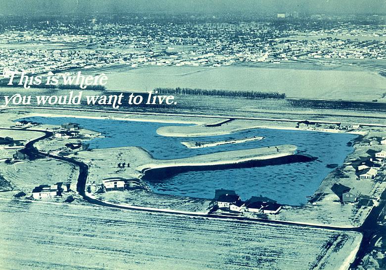
Figure 6a. First Page of Barr & Squires Brochure

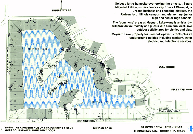
Figure 6b. Second Page of Barr & Squires Brochure
[top]
The second Barr & Squires brochure, apparently later than the above, is seen in Figure 7 below. This shows a ranch house and touts all of the perks of both Maynard Lake and Lincolnshire Fields. There is something for everyone!
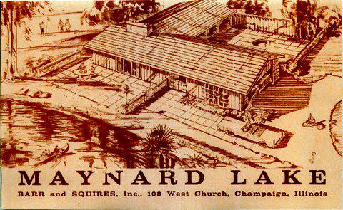
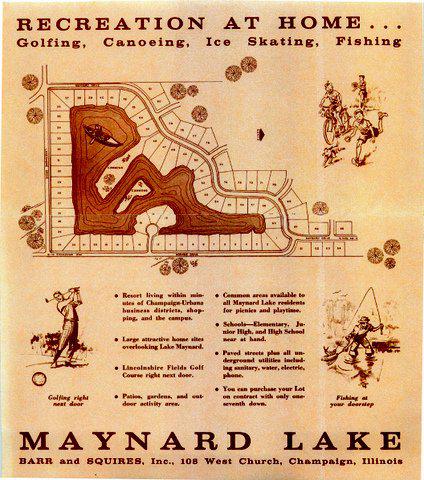
Figure 7. Second Barr & Squires Brochure
Covenants
Abstracts of Title were issued to each owner as the lots were sold. Included in all Abstracts were the Covenants of the Maynard Lake Subdivision, which provided for control of the use of property and also established the Maynard Lake Homeowners’ Association (the MLHA was first mentioned in May of 1967 in the Abstracts of Title for property owners, and it was referred to as “MLHA Corporation”). The MLHA Board of Directors was to consist of six members, three of whom owned lake shore properties and three of whom who owned “off-lake” property. In the early days, when there were relatively few members, most of whom had Lakeshore property, the Maynard Lake Realty Co. appointed three of the required six members, and the residents elected the other three. Among those appointed by the Maynard Lake Realty was at least one of the realty company’s officers, generally the secretary, Joseph Shilling. One of the initial duties assigned to the MLHA was developing a contract for fire protection at $10 per house.
Other governing bodies provided for in the Covenants were the Architectural Control Committee, which approved all proposed plans for property to be built on a site, as well as changes proposed by members who were already homeowners; and the Lake Committee, which maintained the quality of the lake and assured that members followed the Covenants and By-Laws governing treatment of the lake.
Early Pictures of Maynard Lake Subdivision
[top]
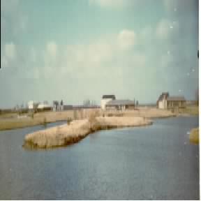
There are a number of pictures showing the early homes that were built, generally surrounded by vacant lots covered with prairie grass. These will be added to this history as they become available. Additional pictures from members will be welcome. The picture in Figure 8 was taken by Carol Le Seure in 1970. It shows the island prior to its landscaping and the new Maynard Drive homes across the lake. The angle from which this picture was taken includes the island as the primary feature in the center, and the peninsula as the land to the left. Identification of the homes is a work in progress. Figure 9 shows an aerial photograph of the early stages of development of both Maynard Lake and Lincolnshire Fields Subdivisions. It is interesting to compare this picture with Figures 1 and 6a. |
|
This picture, contributed by Helen Berner, 3214 Lakeshore Drive, shows a rather extensive view of Lincolnshire golf course with three complete holes and parts of additional holes. Also, Lincolnshire Fields Subdivision shows 11 completed or partially completed homes south of (the middle of) Lakeshore Drive.
For the Maynard Lake Subdivision north of (the middle of) Lakeshore Drive, all of the lakeside roads are complete and a few new homes are seen. On Lakeshore Drive there are homes at 32XX, 32XY and 32 XZ. On Maynard Drive there are homes at 19XX (), 19XX (), 1822 (Hieronymus), 1814 (Dowell) and 1812 (), but no homes yet on Moraine Drive. Thus, this picture was taken before that of Figure 5a. It appears that Moraine Court had not yet been established.
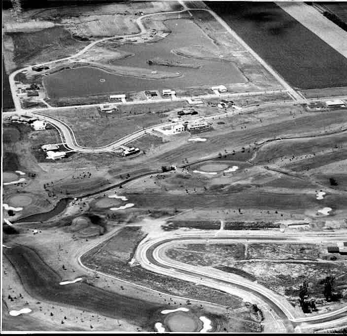
Figure 9. Aerial Photo of Maynard Lake and Lincolnshire Subdivisions, from Helen Berner.
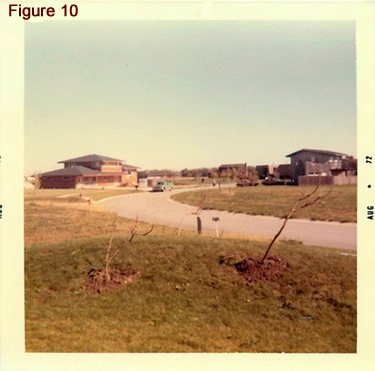
To the left is a 1972 picture provided by Norman Powell, one of the earliest Maynard Lake residents, whose home is at 1833 Maynard Drive. The picture is looking toward the east from his lot prior to the construction of his home.
The home on the left in this picture Figure 10, Maynard Drive is that of Gordon and Joan Paul, now remodeled and currently owned by Jamie and Amy Chesser. The closest home on the right is that of Tom and Julia (Jimmie) Hieronymus at 1822 Maynard, built in 1967. This lot is currently owned by Mark (their son) and Jill Hieronymus, who have replaced the original house.
Beyond the Hieronymus house is that of Jesse and Dorothy Dowell at 1814 Maynard, currently owned by Bill and Clemmie Ackermann. Barely visible beyond the Ackermann house is one built by Gilbert and Stephanie Waldbauer at 1806 Maynard, now owned by Kipp and Janet Pope. The tall house in the distance is that of James and Jean Wixtead on Moraine Drive, currently owned by Jim (JP) and Jennifer Piercy.
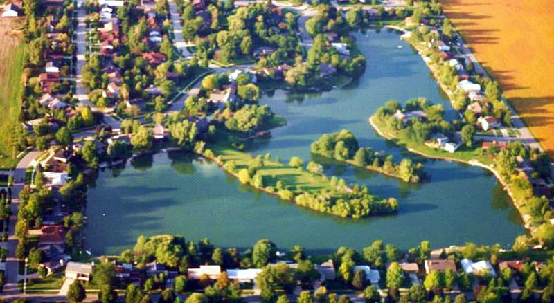
The final image is an aerial view of the Maynard Lake Subdivision as it has appeared in recent years. The iconic picture, which appears throughout the web site, was provided by Mark Zinzow, who used to live at 3318 Lakeshore Dr.
This history is derived from many sources, starting with the Abstracts of Title of Bud and Pat Wingstrom and Carol and Keith Le Seure, all of whom were among the early residents of this Subdivision. The most notable contributor was Art Kenney, a home builder involved in development of real estate in Champaign and Urbana during the period when the Maynard Lake Subdivision was being established. Conversations with Dean Evans, Art Kenney’s early partner, as well as other early residents were also important.
In addition, information was obtained from Jim Welch, an officer of First National Bank in Champaign, which loaned money to the developers of Maynard Lake Subdivision and to other subdivisions as well during the expansion of the Champaign County community to the west during this development period. Rick Schroeder helped us understand the surveyor language in the Abstracts of Title that pertained to the land bought by Westwood, which included the future Maynard Lake Subdivision.
This article was written by Ed Conrad who, with Carol Le Seure, researched the sources mentioned above, which remains a work in progress.
[top]