
If you look down a little, you'll see that this page has undergone a complete transformation, thanks to long hours of work and research by Ed Conrad and Carol Le Seure. (We even went to two pages!) To see what resources they used, check out the text at the bottom of page 2. But I think all will agree that this page tells a much more complete story of our development than it ever did before. Thanks, Ed & Carol!!
|
|
|
|
THE HISTORY OF MAYNARD LAKE SUBDIVISION
Abstract
In the mid-50s and early 60s both Champaign and Urbana were growing communities, with a great deal of the development extending beyond the city limits into the surrounding farm areas. In Champaign a lot of the growth extended westward from Mattis Avenue. Much of the land that was developed was owned by Clarence A. Thompson, owner of Thompson Lumber Co., who established several real estate corporations for building roads and developing new lots for the home builders in the growing population. In the Champaign area, two of these companies were Southwood Corporation, which developed the Southwood Subdivision, just to the west of Mattis Avenue, and Westwood Corporation, which developed the Westwood and Maynard Lake Subdivisions to the west of Duncan Road. At the time of Westwood's purchase of the land that was to become Maynard Lake Subdivision, there was a large abandoned gravel pit in the middle of the land that had been dug out by Dale Parro to obtain the gravel required for his local road-building business. When Westwood Corporation purchased this land, the gravel pit, fed by spring water, had developed into a lake, which they named "Maynard Lake". They then sold a large parcel of the land around the lake to a newly-established company, Maynard Lake Realty Co., which was owned and operated by C. A. Petry and Sons. John Petry, Charles Petry, and Joseph Shilling were named the officers of Maynard Lake Realty Co. which built the roads and sidewalks that surrounded the lake, platted the land for lots, and installed underground utilities to service each lot. These improved lots were sold to those interested in joining this new community. The processes in the development of Maynard Lake Subdivision are described in greater detail in the pages below.
Expansion of Champaign Westward from Mattis Avenue
In the late 50s and early 60s the area that is now west of Mattis Avenue was farm land. As the city of Champaign grew, new residential and commercial areas continued to expand westward, extending the city's boundaries. The history of this development is described in the Champaign County records and, more immediately and to varying degrees, in the abstracts of titles of those homeowners who built homes on properties purchased from the developers of these lots.
Clarence A. Thompson, owner of Thompson Lumber Co., held land west of Mattis Avenue and continued to buy up more of the farm land further west. In July of 1956 Thompson established a real estate company, Southwood Corporation, which was dedicated to buying land and subdividing and developing the land for resale. David Squires was the local manager of Thompson Lumber Co. and was very much involved in these activities. One of the early subdivisions that Thompson established was Southwood, which originally included land along Crescent and Broadmoor Drives and which now extends from ½ mile south of Kirby Avenue to Windsor Road on the south, and from Mattis Avenue on the east to Scottsdale Drive on the west. Southwood Corporation built roads, platted the property, and installed utilities for the lots that were sold to homeowners in this area.
Southwood Corporation continued to acquire land to the west of the original Southwood subdivision. Among these latter properties was a large parcel of the land which is currently occupied by the Maynard Lake and Westwood Subdivisions. In July of 1961 this land was purchased by Southwood Corporation for $71,250 and transferred to Westwood Corporation, a new real estate development company which Thompson created and which was recognized by the State of Illinois in 1961. Donald V. Dobbins, a local attorney, served as the registered agent for Westwood Corporation. Most of the land owned by Westwood was undeveloped farm land except for a huge abandoned gravel pit lying near the center of the property.
The Westwood Subdivisions
As the first stage of development of this new land, Westwood Corporation established Westwood I and Westwood II Subdivisions on July 1, 1961 and January 2, 1962, respectively. The homes built in the Westwood Subdivisions were all rental units. Together these two subdivisions are bounded by Holmstrom Street on the west, Kirby Avenue on the north, Maynard Drive on the east, and the full length of both sides of Halifax Drive on the south. These subdivisions are just north of the current Maynard Lake Subdivision.
[top]
This gravel pit, fed by spring water, had gradually become a lake. First some background on the gravel pit: When Westwood acquired the property, the gravel pit contained no more gravel and had been abandoned. The pit had been owned by Dale Parro's road-building company, The Parro Construction Corporation, housed in Urbana, IL. Parro's company owned two other companies, Urban Sand and Gravel, and Hi-Way Hauling, both of which were involved in the road building operations. As these companies removed gravel from the area and hauled it away for road construction, eventually they encountered "blue mud"—a clay that is of no value for the road-building process. Thus, the gravel pit was abandoned in the early 1960s but the remaining area was a large hole with depths varying from 10 to 15 feet, which had slowly filled with water from springs exposed by the gravel-digging operations. This was part of the parcel of land acquired by Westwood Corporation, as noted above.
It has been difficult to find much information about Dale Parro, but one tragic event has led us to much that we have described above. In April of 1966, several years after the gravel pit was abandoned, Dale Parro and George Smith, an employee of the Parro Construction Co., rented a plane and, with Parro as the pilot, flew to Madison, Indiana to inspect some equipment that they felt might be of value in the continuing operations of the company.
On April 16, 1966, as they were taking off from Madison to return to Urbana, their plane crashed, and the two men died in the crash. Pictures from this sad event are available from old Courier pages found in the Urbana Library. Following the probating of Parro's will, there was a court case in which the surviving spouses brought suit against the Parro Construction Co. in order to claim workmen's compensation insurance following the loss of their spouses (see
http://il.findacase.com/research/wfrmDocViewer.aspx/xq/fac.19700520_0000481.IL.htm/qx). It is from the on-line description of this case that we have learned much about Dale Parro.
The Early Appearance of the Lake
An aerial view of the lake prior to its further development as the centerpiece of Maynard Lake Subdivision is shown in Figure 1 below (contributed by Cam Dobbins, a prior resident of the Maynard Lake Subdivision). This picture, published in the News-Gazette, was taken after Westwood Corporation, through an agreement with the Phinney Branch Mutual Drainage District, had attached an outlet pipe at the southeast corner of the lake to drain water from the lake into the Phinney Branch. This outlet is used to maintain the lake level during periods of heavy precipitation. The drain installation was completed in November of 1965.
It may also be noted that, the lake level continued to be a problem after the earliest residents had built their homes and the Maynard Lake Homeowners Association became organized. The fluctuations in lake level were addressed in 1970 and the Maynard Lake Realty Co. was asked to deal with these concerns.
In order to address this problem, a pump was installed near Kirby Avenue in the Bian Park area to the north of the lake. This pump was used to transfer water from the aquifer through an underground pipe running from the pump into the northeast side of the lake. Today this pump is used to restore lake levels in dry weather periods, whereas the Phinney Branch outlet in the southeast corner of the lake is used to maintain the lake level during periods of heavy precipitation.
There are several points of interest here. First, the photo includes both Maynard Lake at the top and a portion of Lincolnshire Fields subdivision and golf course at the bottom. Both of these subdivisions were developing simultaneously, although Lincolnshire Fields was further along. The lake is complete with, from left to right, its projecting peninsula, its island, and the projection of what would become Moraine Circle.
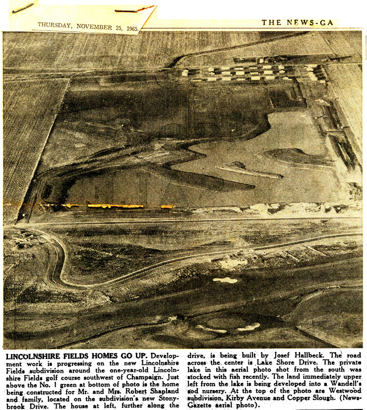
Figure 1. Early Picture of Maynard Lake and Lincolnshire
[top]
Lakeshore Drive, which bisects this photo, is the dividing line between the Lincolnshire Fields and Maynard Lake Subdivisions, with Lincolnshire Fields on the south side of the street and Maynard Lake on the north side. There are no other roads around the lake, nor is any further lakeside road construction yet under way. The caption for this photo notes, to the west of the lake, the Wandell sod nursery, an area that is now a part of Minor Lake Subdivision. The caption also notes Kirby Avenue and the Copper Slough at the top of the photo, and the Westwood Subdivisions, already built just south of Kirby Avenue. Bian Park, where the pump for Maynard Lake is located, is just to the west of Westwood Subdivision I.
The lower portion of this photo shows the newly built Lincolnshire Fields golf course and the early stages of the Lincolnshire Fields Subdivision. As the caption of this picture describes, Stoneybrook Drive is shown with the beginnings of a house built by the Robert Shapland, the developer of Lincolnshire Fields, and, to the far left, a home under construction by Josef Hallbeck, who lived in this house for several years after this picture was taken, and then sold it to Michael O'Byrne, who continues to live there at the time of this writing. Michael O'Byrne was the attorney for the developers of Maynard Lake Subdivision.
Don Dobbins, the attorney for Westwood Corporation, and Dave Squires, who was the manager for Thompson Lumber Co., were good friends who loved to fish. Often they would travel on fishing expeditions to their favorite place in Ontario, Canada. There they fished at a lake called "Maynard Lake". (This is really true; see http://www.maynardlake.com/.) Since both Dobbins and Squires were involved in Westwood Corporation development of the Clarence Thompson property in Champaign, and since they had a new lake that needed a name, they decided to use the name of their favorite Canadian lake for the Champaign gravel-pit-turned-lake. Thus the new lake in Champaign County was named Maynard Lake. Chuck Petrie (below), who was involved in the development of the new Champaign County Maynard Lake subdivision, was also a fisherman who accompanied Dobbins and Squires on some of the Ontario trips.
As an interesting aside, Holmstrom Street, along the western end of the Westwood I Subdivision (see above) was named after the cook at the Ontario Maynard Lake Lodge
The conversion of the Maynard Lake area into Maynard Lake Subdivision was accomplished by Maynard Lake Realty Company, a company whose objective was to build roads, plat lots, install utilities, and sell the improved lots. On June 15, 1966 a Certificate of Authority was issued to Maynard Lake Realty Co. by the State of Illinois. Maynard Lake Realty was owned and operated by C. A. Petrie and Sons, a local contractor. John Petry, Charles Petry, and Joseph Shilling were named as officers of the new company, and their lawyer, J. Michael O'Byrne, as the registered agent. Westwood Corporation had agreed to sell a parcel of land around the lake to this newly established company.
On July 1, 1966 Westwood Corporation issued a Warranty Deed to Maynard Lake Realty Co. and, on the same day, Maynard Lake Realty Co. borrowed $275,000 from First National Bank of Champaign for purchase of the property. Maynard Lake Realty Co. agreed to pay off the loan in 10 promissory notes over the next 5 years. These payments were made to the bank and transferred from the bank to Westwood Corporation. As the loan was paid off, new lots (or groups of lots) were released to Maynard Lake Realty Co. by First National Bank and these lots were developed for further sales.
At the time of the purchase of the Westwood property, Urban Sand and Gravel and Twin City Nurseries each rented a portion of the Maynard Lake land. The property rights of Urban Sand and Gravel Co. and Twin City Nursery, Inc. were terminated in 1966 and on December 1, 1967 respectively, making the land available for further expansion of the Maynard Lake Subdivision.
Early Stages of Maynard Lake Subdivision Development
Following the purchase of the land, many further developments were required to convert this property to lots that could be sold for home construction. These needs are apparent from Figure 2, which shows two images of the barren space around the lake prior to the time when any significant development of the subdivision had taken place (again, contributed by Cam Dobbins). The viewer(s) may decide (or debate) the locations from which these pictures were taken.
[top]
Figure 2a
|
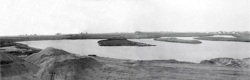
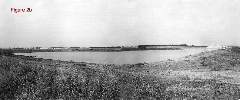
Figures 2a and 2b showing the land around Maynard Lake prior to early development
Development of the lots around the lake required grading the property; building roads and sidewalks; platting lots; and installing underground storm drains, sanitary sewers, telephone lines, electric lines, tile, and water and gas lines. In early January of 1967, Maynard Lake Realty was authorized to perform all of these functions around the lake. As an early stage, the land around the lake was platted by surveyor Charles S. Danner. Maynard Lake Realty Co. then added the roads, sidewalks, and utilities for each lot. Addition of the roads was not without some legal problems as indicated in Figure 3, which shows a May 5, 1965 article from the News-Gazette below (again contributed by Cam Dobbins).
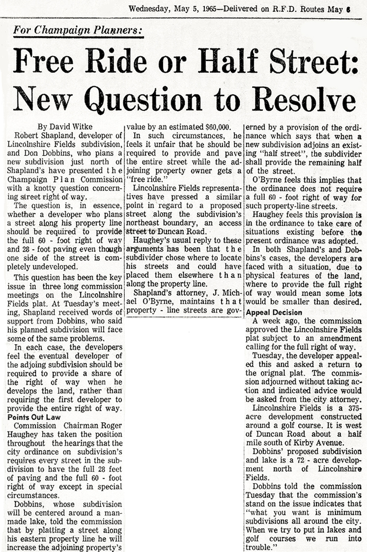
Figure 3. Streets, or Half-Streets?
[top]
The Further Development of Maynard Lake Subdivision
What is now the full Maynard Lake Subdivision was developed in a sequence of six sections ("subs 1-6" in Figure 4), with the initial lots being sold in sections 1 and 2 along Lakeshore Drive and the southern part of Moraine Drive. These were followed by lots in sections 3 and 4 along Maynard Drive. Finally new roads and sidewalks and lots were established in sections 5 and 6 along Bridgestone, Coventry, and Roxford Drives. As each section was completed, its lots were made available for sale and the next section was established. These sequential subdivisions are shown here on the plat map below.
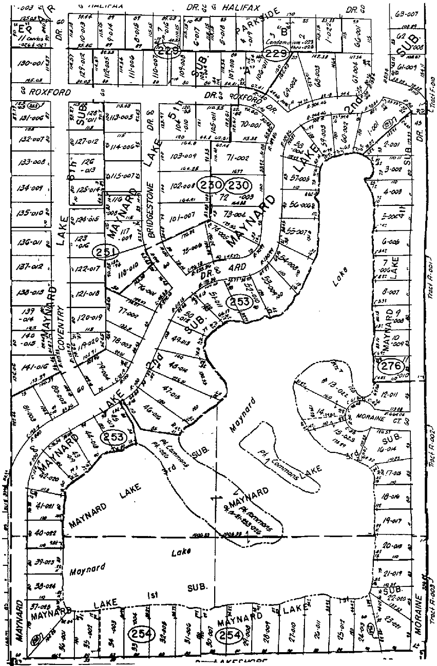
Figure 4. Plat Map of Current Maynard Lake Subdivision
Note: This plat map is available full-sized on the page called "Lot Map".
[top]
Last Modified:
Webmaster